Timegate as a partner in the H2020 Goldeneye project
Improved safety, efficiency, and a lower environmental impact – ambitious EU project combines research and business to reshape Europe’s mining industry.
The European Commission has granted EUR 8.4 million to a three-year H2020 project that develops an artificial intelligence platform for the monitoring and analysis of mine sites across Europe. The project, called Goldeneye, will develop solutions that improve safety, environmental impact and profitability of mines by creating a platform that combines earth observation technologies with on-site sensing. 
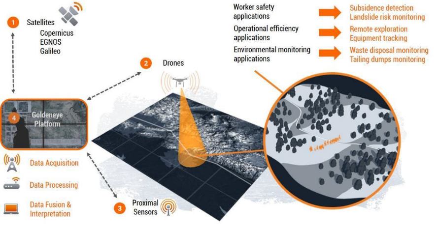
European production and infrastructure depend on a supply of high-quality raw materials. Ensuring that the needed materials are produced responsibly in European mines guarantees sustainable supply and prevents European countries from becoming dependent upon imports from global markets. To support the development of the European mining industry through technological solutions, the Goldeneye platform integrates information from satellite produced Earth Observation Data (EOD), drone overflight sensors and on-site recorded data.
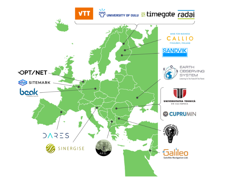
The project is coordinated by VTT Technical Research Centre of Finland and the consortium consist of 16 European companies and research partners. The consortium works together in platform development and in bringing together the work of sensing experts, solution providers, and European mines.
Combining data to minimize risks
The Goldeneye project will implement a unique combination of remote sensing and positioning technologies with data analytics and machine-learning algorithms. The platform will allow satellites, drones and in-situ sensors to collect high-resolution data of the entire mine, which can then be processed and converted into actionable intelligence that allows more efficient exploration, extraction and closure.
“With Goldeneye, we are not solving just one problem. Our goal is to bring together different technologies in a platform that can offer innovative solutions to both businesses and governments and have a positive effect on the mining industry as a whole,” says the project coordinator Marko Paavola from VTT.
Goldeneye platform for comprehensive monitoring of mining sites
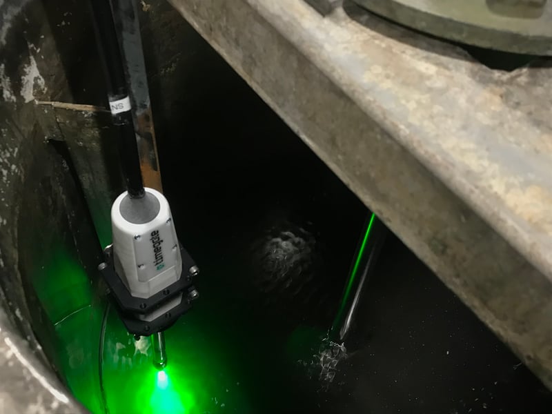
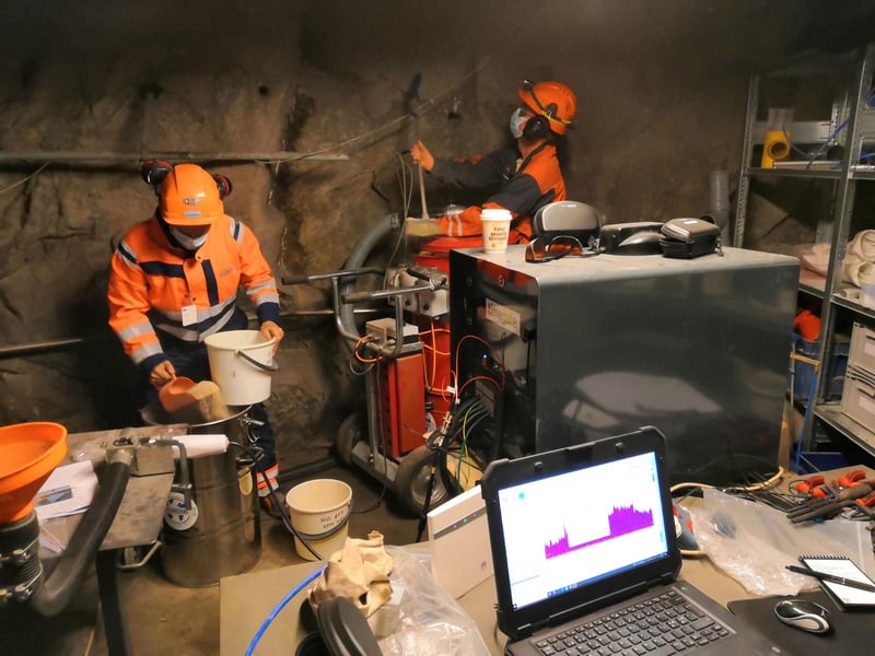
The project will also improve the analysis of the mine site mineralogy using drone integrated geophysical sensors as well as innovative proximity sensors including active hyperspectral sensing and time resolved Raman spectroscopy. The platform integrates this information to the data gained from the imagery and radars of available satellites including Copernicus and Sentinel systems as well as global satellites.
Applications for every stage of the lifecycle
The use cases of the Goldeneye platform address the different phases of the mine’s life cycle from exploration to closure and post-closure. The applications developed in the project include mineral detection, safety monitoring, operational management, geo-hazard monitoring, and environmental monitoring.
For example, in the safety monitoring application the aim is to improve the safety of the mines by monitoring the mining sites for sudden slope and ground changes as well as analysing the environment of the mines to detect any mining water leakages from their indirect influence to the surrounding nature.
Five pilot sites across Europe
During the project, the Goldeneye platform will be piloted on five mining sites across Europe. Two pilot sites, Pyhäsalmi mine in Finland and Trepča Mines Complex in Kosovo will focus on the study of the environmental impact and stability of the mines. The Pyhäsalmi mine will also be used as a test site for indoor GNSS location positioning and turn-by-turn navigation. Accurate location improves the safety of the underground mines as it enables better tracking of the mining activities.
Two field trial sites, Erzgebirge district in Germany and Panagyurishte district in Bulgaria, will focus on mineralogical mapping. The geophysical and proximity sensors will be used to calibrate satellite information and teach AI algorithms. The aim is to develop mineral exploration with higher resolution imaging and improved mapping of valuable mineral deposits.
The fifth site in the Roşia Poieni district in Romania aims to improve mineral predictions with combined satellite imagery and drone-produced data. The aim is to improve profitability, and support the mining community of the area.
Furthermore, the project will develop a mineralogical sensor solution for the ore drilling integrating Sandvik drilling machines with time-gated Raman sensors. This will improve the mineral extraction efficiency and support the profitability of the mines.
Consortium partners:
AKG sh.p.k, Beak Consultants, Cuprumin, Dares Technologies, Earth observing system, Galileo Satellite Navigation, OPT/NET, Radai, Sandvik Mining and Construction, Sinergise, Sitemark, Technical University of Cluj Napoca, Timegate Instruments, University of Oulu and University of Sofia
Additional information:
Marko Paavola
Project coordinator
VTT
+358401271842
marko.paavola@vtt.fi
Korab Tmava
Team Leader
AKG sh.p.k.
+383 49 595 594
tmavakorab@gmail.com
https://cordis.europa.eu/project/id/869398